The calculation of the radius of the Earth by Eratosthenes of Cyrene (276 BC – 194 BC) remains one of the most striking applications of elementary geometry, despite the fact that more than two thousand years have passed since then.

Eratosthenes was told that in Syene, the present-day Aswan, at noon on the summer solstice, the sun’s rays fell perpendicularly on the Earth, to such an extent that they produced no shadows and entered the depths of the wells: if there had been one that reached the centre of the Earth, the light of the Sun would have penetrated there. But, at noon of the summer solstice, the bodies produced shadows in Alexandria, situated 5,000 stadia north of Syene; that is to say, those same rays of the Sun did not fall perpendicular but formed a certain angle with the perpendicular which Eratosthenes knew how to measure; and it measured 7º 12′, more or less. The circumference covers an angle of 360º, that is, about 50 times the angle of 7º 12′. Eratosthenes deduced that the maximum circumference of the Earth would also be 50 times greater than the distance separating the two cities: that is, it must measure 250,000 stadia, which gives a distance of 39,773 stadia for the radius of the Earth (using the approximation 22/7 for π that Archimedes had already calculated at that time).
We do not know which stadia measurement Eratosthenes used in his estimate (measurements in antiquity were not standardised), but using the most likely variants, Eratosthenes’ estimate for the radius of the Earth would be between 6,244 and 7,358 km. A surprisingly good estimate, considering that the radius of the Earth is about 6,378 km.
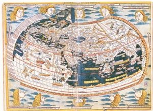
 That of Eratosthenes was not the only estimate the Greeks made of the size of the Earth. For example, the great Greek mathematician, astronomer and geographer Ptolemy (85 AD-165 AD) made another one. He included it in his book Geography. This work by Ptolemy, unlike others of his (Almagest, Tetrabiblos), did not reach the West until Florentine expeditionaries brought it back from Constantinople in 1400. Ptolemy’s Geography, which included a set of twenty-six maps and a world map, would later be published in splendid printed editions. Ptolemy, however, included in his book an estimate of the size of the Earth that was considerably more inaccurate than that of Eratosthenes; in particular, he made the Earth considerably smaller than it actually is.
Ptolemy’s map of the world was reworked by the Florentine Paolo dal Pozzo Toscanelli (1397-1482). It has never been proven, but it is possible that Christopher Columbus had access to a letter from Toscanelli that included his world map and Ptolemy’s estimates; this letter was mentioned by Fray Bartolomé de las Casas in his Historia de las Indias and by Hernando Columbus, the illegitimate son of the admiral and the young Cordovan woman Beatriz Henríquez. In 1871, a copy of Toscanelli’s letter, dated 1474, presumably from the hand of Christopher Columbus himself, was found in the Biblioteca Capitular y Colombina in Seville, founded with the magnificent collections bequeathed by Hernando Columbus. Toscanelli’s letter, the book Imago Mundi by the Frenchman Pierre d’Ailly (1350-1420), the Historia Rerum by Pope Pius II Picolomini, Marco Polo’s The Book of Wonders – which he dictated to Rustichelo of Pisa when they were both prisoners of the Genoese, and which is often quoted in Toscanelli’s letter – and Pliny’s Natural History, led Columbus to deduce that the Earth had a circumference of 24,000 km – i.e. a radius of approximately 3,820 km). All these books are preserved in the Biblioteca Colombina and contain numerous annotations in the handwriting of Christopher Columbus – about 900 are in the copy of the d’Ailly book, a copy printed in Louvain in the third quarter of the 15th century.
The 16,000 km shortfall that Columbus calculated to the circumference of the Earth, that unforgivable miscalculation, resulted in the discovery of a world: the one that prevented him from sailing directly west from Spain to Cipango.

Muy buen artículo e interesantísimo además, felicito ampliamente al redactor del mismo y por favor continúe con esa extraordinaria literatura !!!!!
excelente articulo!
Yo siempre me hahia preguntado si Colon conocia los datos de Eratostenes,
y me decia como es posible se arriegara a cruzar tanto mar . Al parecer el director de la Biblioteca de Alejandria (Erastostenes) archivo sus conclusiones
y la destruccion de la Biblioteca sepulto ese documento original,
Alguna copia de ese original quedo en algun lugar descubierta posteriorment
El conocimiento historico no es lineal algun dia sabremos de las herramientas que esculpieron la durisima piedra de los monumentos antiguos
Literal muy buen articulo además abarca bastante información, el contexto es comprensible, viable y conciso, igualmente felicito al redactor del mismo
Este error de cálculo fue de hecho la razón por la que se rechazara inicialmente el proyecto de Colón en Salamanca, ver https://revistas.um.es/navegamerica/article/view/44001 y https://www.religionenlibertad.com/blog/25333/de-la-junta-de-salamanca-que-analizo-el-proyecto-colombino-en.html